
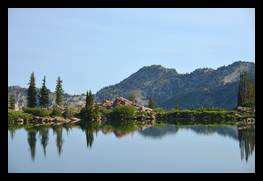
View Medium or Large image.
Cecret Lake is high in the mountains above Little Cottonwood Canyon. Even though it is August, there is still a small patch of snow behind the lake.
Date: July 26, 2014
Location: Cecret Lake, Little Cottonwood Canyon, Alta, UT
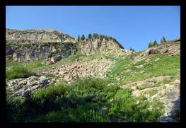
View Medium or Large image.
The mountain above Cecret lake has boulder fields and shear cliffs.
Date: July 26, 2014
Location: Cecret Lake, Little Cottonwood Canyon, Alta, UT
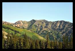
View Medium or Large image.
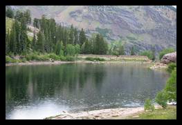
Cecret lake is part way up a mountain, so from one side of it you can look across and see the mountains on the other side of the valley.
Date: July 26, 2014
Location: Cecret Lake, Little Cottonwood Canyon, Alta, UT
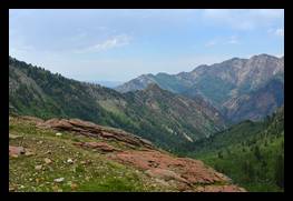
View Medium or Large image.
Litle Cottonwood Canyon as seen from Cecret Lake.
Date: July 26, 2014
Location: Cecret Lake, Little Cottonwood Canyon, Alta, UT
View Medium or Large image.
Looking down the canyon, the trail you come up on is to the right.
Date: July 20, 2014
Location: Lake Blanche, Big Cottonwood Canyon, Brighton, UT
View Medium or Large image.
While we were there it started to rain, not very hard, but enough to cool us down.
Date: July 20, 2014
Location: Lake Blanche, Big Cottonwood Canyon, Brighton, UT
View Medium or Large image.
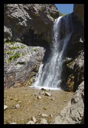
Adams Canyon is a nice hike up a canyon ending in this 40 foot tall waterfall.
Date: July 26, 2015
Location: Adams Canyon, Layton, UT
View Medium or Large image.
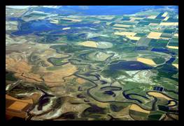
Oxbow lakes and the Bear River. Oxbow lakes occur when the river cuts across one of its meanders, cutting off that part of the river and leaving a lake that is shaped a bit like an oxbow. I have never seen that many in the same place before.
Date: July 26, 2015
Location: Box Elder County, UT
View Medium or Large image.
the stream disappears into the hole of donut falls, then you can see the base of the falls in the cavern.
Date: July 27, 2015
Location: Donut Falls Trail, Big Cottonwood Canyon, UT
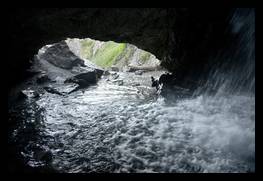
View Medium or Large image.
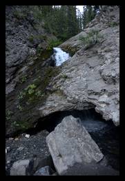
From inside the cavern you see the stream leaving the cave, and on the right, the water is falling from outside.
Date: July 27, 2015
Location: Donut Falls Trail, Big Cottonwood Canyon, UT
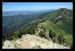
View Medium or Large image.
The trail up Mt Raymond is steep, and there is a lot of elevation change. The reward is the great views alng the way. This is looking back at the trail, it goes along the very top of the ridge, across the rocks and green grass.
Date: July 16, 2016
Location: Mount Raymond, Cottonwood heights, UT
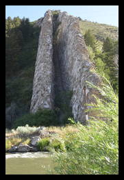
View Medium or Large image.
Devil's slide is an unusual rock formation consisting of two parallel fins of rock that run vertically up the side of a hill. The fins are about 25 feet (7.6 meeters) apart and run hundreds of feet up the side of the hill. It is located in the Weber Canyon area of northern Utah and is visible from interstate I-84, about 45 minutes outside of Salt Lake City, Utah, there are pullouts in both directions on the interstate so you can stop and take a look.
Date: July 17, 2016
Location: I-84, Weber Canyon, UT
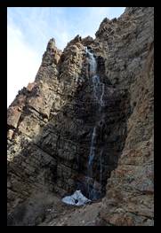
View Medium or Large image.
At the top of waterfall canyon there is a waterfall. It is hidden until you are almost there. It is tall, but doesn't usually have a large flow of water. I went there once in July and it was just a trickle, this picture was taken in April and there was a bit more water.
Date: April 19, 2018
Location: Waterfall Canyon, Ogden, UT
View Medium or Large image.
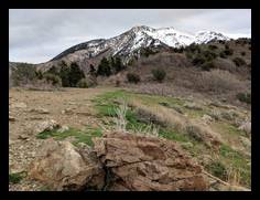
The Malan's Peak trail gives you plenty of beautiful views, you can look down over the valley and see Ogden, UT below you, or you can look up and see the mountains around you.
Date: April 19, 2018
Location: Malan's Peak Trail, Ogden, UT